
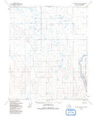
1955 Map of Mount Michelson D-5
USGS Topo · Published 1964About this map
The Canning River carves a massive, braided corridor through this landscape in the mid-1950s, serving as a defining boundary and a vital water source in this northern terrain. This area was designated as part of the Arctic National Wildlife Range, reflecting a period when federal land management was solidifying conservation priorities in Alaska's interior. The terrain is characterized by a dense network of small, unnamed lakes and ponds that dominate the northern flats, transitioning into more defined elevation contours to the south. Mapped by the Army Map Service and published by the Geological Survey, the sheet illustrates the unsurveyed and unmarked locations predetermined by the Bureau of Land Management during this era. The concentration of wetlands and the shifting nature of the river channels highlight the hydrological complexity of the region before further modern human intervention or more detailed infrastructure were established.
Find a feature on this map
2 named features on this map. Tap any name to fly to it.
Don’t see what you’re looking for? This feature index may not catch every label — zoom into the map to look around manually.
Map Details
Editions of this 1955 Mount Michelson D-5 Map
2 editions found
Other maps of this area

1951 · Beechey Point
USGS Topo · 1:250,000

1951 · Sagavanirktok D-5
USGS Topo · 1:250,000

1951 · Mt. Michelson
USGS Topo · 1:250,000

1955 · Flaxman Island
USGS Topo · 1:250,000

1955 · Beechey Point
USGS Topo · 1:250,000

1955 · Mount Michelson C-5
USGS Topo · 1:63,360

1955 · Mount Michelson C-4
USGS Topo · 1:63,360

1955 · Mount Michelson D-4
USGS Topo · 1:63,360

1955 · Flaxman Island A-5
USGS Topo · 1:63,360

1955 · Beechey Point A-1
USGS Topo · 1:63,360