
1955 Map of Mount Michelson C-4
USGS Topo · Published 1964About this map
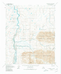
Arctic National Wildlife Range dominates this mid-century topographic survey, revealing the remote landscape of Alaska's North Slope before modern development altered the region. The drainage of the Canning River carves through the western portion of the map, serving as a primary hydrologic corridor between the southern peaks and the northern coastal plain. The terrain is defined by the massive uplift of the Sadlerochit Mountains and the Shubelik Mountains, with Mount Copleston rising as a prominent landmark. Between these ranges, the Ignek Valley and the waters of Nanook Creek and Ignek Creek illustrate the glacial and fluvial processes that shaped this wilderness. This 1955 survey captures the area in a purely wild state, showing unsurveyed land lines predetermined by the Bureau of Land Management for one of the most remote corners of the American frontier.
Find a feature on this map
9 named features on this map. Tap any name to fly to it.
Don’t see what you’re looking for? This feature index may not catch every label — zoom into the map to look around manually.
Map Details
Editions of this 1955 Mount Michelson C-4 Map
2 editions found
Other maps of this area

1951 · Mt. Michelson
USGS Topo · 1:250,000

1955 · Mount Michelson C-5
USGS Topo · 1:63,360

1955 · Mount Michelson C-3
USGS Topo · 1:63,360

1955 · Mount Michelson D-5
USGS Topo · 1:63,360

1955 · Mount Michelson D-3
USGS Topo · 1:63,360

1955 · Mount Michelson D-4
USGS Topo · 1:63,360

1956 · Mt. Michelson
USGS Topo · 1:250,000

1956 · Mount Michelson B-3
USGS Topo · 1:63,360
1971 · Mount Michelson B-5
USGS Topo · 1:63,360
1973 · Mount Michelson C-5
USGS Topo · 1:63,360