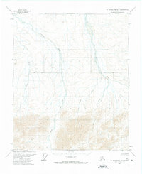
1971 Map of Mount Michelson B-5
USGS Topo · Published 1973About this map
Kavik River and Juniper Creek define the northern drainage of this North Slope wilderness, where glacial activity and permafrost shaped the landscape before any modern development reached the area. This 1971 aerial-photogrammetric survey records a territory devoid of roads or permanent structures, divided by the east-west Base Line survey marker. The terrain transitions from broad, braided alluvial fans in the north to increasingly complex topography in the south, where Pogopuk Creek and Cobble Creek originate in the high ground. Small, unnamed drainages like Fin Creek feed into the larger water systems, illustrating the intricate hydrology of the Arctic coastal plain's foothills during the early 1970s.
Find a feature on this map
6 named features on this map. Tap any name to fly to it.
Don’t see what you’re looking for? This feature index may not catch every label — zoom into the map to look around manually.
Map Details
Editions of this 1971 Mount Michelson B-5 Map
This is the sole edition of this map. No revisions or reprints were ever made.
Other maps of this area

1951 · Sagavanirktok D-5
USGS Topo · 1:250,000

1951 · Mt. Michelson
USGS Topo · 1:250,000

1955 · Mount Michelson C-5
USGS Topo · 1:63,360

1955 · Mount Michelson C-4
USGS Topo · 1:63,360
1955 · Sagavanirktok C-1
USGS Topo · 1:63,360

1956 · Mt. Michelson
USGS Topo · 1:250,000

1956 · Sagavanirktok
USGS Topo · 1:250,000

1958 · Sagavanirktok
USGS Topo · 1:250,000

1964 · Sagavanirktok
USGS Topo · 1:250,000
1971 · Sagavanirktok A-1
USGS Topo · 1:63,360