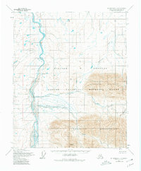
1955 Map of Mount Michelson C-4
USGS Topo · Published 1980About this map
The Canning River defines the western edge of this subarctic landscape, situated within the William O Douglas Arctic National Wildlife Range. This 1955 photogrammetric survey reveals a terrain dominated by the massive east-west ridges of the Sadlerochit Mountains and the Shublik Mountains, separated by the broad expanse of Ignek Valley. The presence of a Drill Hole along the riverbank north of Red Hill points to early resource exploration efforts on the North Slope during the mid-20th century. High peaks like Mount Copleston anchor the southern reaches of the map, while numerous drainages including Nanook Creek, Ignek Creek, and Hue Creek carve through the mountain passes. The map reflects a period before intensive infrastructure, showing a land navigated by its waterways and natural landmarks such as the Tamayariak River.
Find a feature on this map
12 named features on this map. Tap any name to fly to it.
Don’t see what you’re looking for? This feature index may not catch every label — zoom into the map to look around manually.
Map Details
Editions of this 1955 Mount Michelson C-4 Map
2 editions found
Other maps of this area

1951 · Mt. Michelson
USGS Topo · 1:250,000

1955 · Mount Michelson C-5
USGS Topo · 1:63,360

1955 · Mount Michelson C-3
USGS Topo · 1:63,360

1955 · Mount Michelson D-5
USGS Topo · 1:63,360

1955 · Mount Michelson D-3
USGS Topo · 1:63,360

1955 · Mount Michelson C-4
USGS Topo · 1:63,360

1955 · Mount Michelson D-4
USGS Topo · 1:63,360

1956 · Mt. Michelson
USGS Topo · 1:250,000

1956 · Mount Michelson B-3
USGS Topo · 1:63,360
1971 · Mount Michelson B-5
USGS Topo · 1:63,360