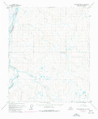
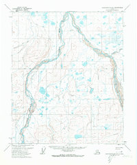
1971 Map of Sagavanirktok A-3
USGS Topo · Published 1977About this map
Sagavanirktok River and its tributary, the Lupine River, dominate this North Slope terrain during a period of massive industrial transformation. The map documents the early infrastructure of the North Slope oil boom, specifically noting The Trans-Alaska Pipeline while it was still (UNDER CONSTRUCTION). This industrial corridor is further supported by a Winter Road and a remote Landing Strip, illustrating the logistical challenges of Arctic development. Above the river basin, the Kakuktukruich Bluff provides a significant geographic anchor. While the landscape is largely characterized by vast drainage patterns and muskeg, the inclusion of a Gaging Sta and a Tower reflects the scientific and communication network required to support the pipeline's path through the Alaskan wilderness.
Find a feature on this map
9 named features on this map. Tap any name to fly to it.
Don’t see what you’re looking for? This feature index may not catch every label — zoom into the map to look around manually.
Map Details
Editions of this 1971 Sagavanirktok A-3 Map
2 editions found
Other maps of this area

1951 · Sagavanirktok D-5
USGS Topo · 1:250,000

1951 · Brooks
USGS Topo · 1:250,000

1956 · Philip Smith Mountains
USGS Topo · 1:250,000

1956 · Sagavanirktok
USGS Topo · 1:250,000

1958 · Sagavanirktok
USGS Topo · 1:250,000

1964 · Philip Smith Mountains
USGS Topo · 1:250,000

1964 · Sagavanirktok
USGS Topo · 1:250,000
1971 · Sagavanirktok B-4
USGS Topo · 1:63,360
1971 · Philip Smith Mountains D-3
USGS Topo · 1:63,360
1971 · Sagavanirktok B-3
USGS Topo · 1:63,360