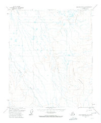
1971 Map of Sagavanirktok A-5
USGS Topo · Published 1973About this map
Kuparuk River winds through this Arctic landscape, defining the western drainage of a region shaped by permafrost and glacial action. The terrain is dominated by the massive presence of Kakukturat Mountain to the southeast, where the elevation rises significantly above the surrounding tundra. This 1971 survey captures the area just as modern infrastructure began to touch the North Slope. A solitary Winter Trail marks the only established passage through the northern section, reflecting the seasonal nature of movement in a landscape where frozen ground and snow provided the primary means of transport across the wetlands and braided river systems before permanent roads were established.
Find a feature on this map
3 named features on this map. Tap any name to fly to it.
Don’t see what you’re looking for? This feature index may not catch every label — zoom into the map to look around manually.
Map Details
Editions of this 1971 Sagavanirktok A-5 Map
This is the sole edition of this map. No revisions or reprints were ever made.
Other maps of this area

1951 · Sagavanirktok D-5
USGS Topo · 1:250,000

1951 · Chandler Lake
USGS Topo · 1:250,000

1951 · Brooks
USGS Topo · 1:250,000

1952 · Umiat
USGS Topo · 1:250,000

1956 · Philip Smith Mountains
USGS Topo · 1:250,000

1956 · Chandler Lake
USGS Topo · 1:250,000

1956 · Sagavanirktok
USGS Topo · 1:250,000

1956 · Umiat
USGS Topo · 1:250,000

1958 · Sagavanirktok
USGS Topo · 1:250,000

1964 · Philip Smith Mountains
USGS Topo · 1:250,000