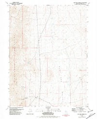
1981 Map of Sage Hen Spring
USGS Topo · Published 1982About this map
The Nightingale Mountains dominate the western horizon of this high-desert landscape, where mining activity defined the local economy through the late 20th century. Toward the southern end of the range, the Nightingale (Site) marks the remains of a once-active settlement, anchored by the nearby Nightingale Mine and several other unlabeled Mines and Mines scattered along the slopes. These mining operations relied on scarce water sources like Sage Hen Spring and occasional developments such as a Dry Well or standard Well in the flats.
Find a feature on this map
12 named features on this map. Tap any name to fly to it.
Don’t see what you’re looking for? This feature index may not catch every label — zoom into the map to look around manually.
Map Details
Editions of this 1981 Sage Hen Spring Map
This is the sole edition of this map. No revisions or reprints were ever made.
Other maps of this area

1886 · Granite Range
USGS Topo · 1:250,000

1890 · Wadsworth
USGS Topo · 1:125,000

1892 · Wadsworth
USGS Topo · 1:125,000

1894 · Granite Range
USGS Topo · 1:250,000

1894 · Wadsworth
USGS Topo · 1:125,000

1955 · Lovelock
USGS Topo · 1:250,000

1957 · Fireball Ridge
USGS Topo · 1:62,500

1957 · Nixon
USGS Topo · 1:62,500

1957 · Reno
USGS Topo · 1:250,000

1959 · Lovelock
USGS Topo · 1:250,000