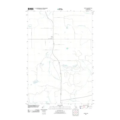
2011 Map of Sagola
USGS Topo · Published 2011About this map
The settlement of Sagola serves as the primary hub in this northern Michigan landscape, situated at the intersection of local logging-era routes and modern transport lines. The area is defined by its complex hydrography, specifically the convergence and winding paths of the West Branch Sturgeon River and the North Branch Sturgeon River, which dominate the central and eastern portions of the quadrangle. The Sagola Post Office marks the center of local civic life, while the surrounding terrain is dotted with numerous small bodies of water, including Section Nine Lake, Tamarack Lake, and Gestner Lake. In the northern reaches, the Ford River cuts across the land, further emphasizing the importance of river drainage systems to the historical development of Dickinson County. The map provides a clear view of the grid-like road system, such as Wells Grade Rd and Bush Lake Rd, which provide access to more remote water features like Holmes Lake.
Find a feature on this map
28 named features on this map. Tap any name to fly to it.
Don’t see what you’re looking for? This feature index may not catch every label — zoom into the map to look around manually.
Map Details
Editions of this 2011 Sagola Map
This is the sole edition of this map. No revisions or reprints were ever made.
Other maps of this area

1899 · Sagola
USGS Topo · 1:62,500

1939 · Iron Mountain
USGS Topo · 1:48,000

1941 · Iron Mountain
USGS Topo · 1:48,000

1947 · Iron Mountain
USGS Topo · 1:48,000

1947 · Kiernan
USGS Topo · 1:24,000

1947 · Lake Mary
USGS Topo · 1:24,000
1949 · Commonwealth
USGS Topo · 1:24,000

1954 · Iron Mountain
USGS Topo · 1:250,000

1954 · Escanaba
USGS Topo · 1:250,000

1955 · Ralph NW
USGS Topo · 1:24,000