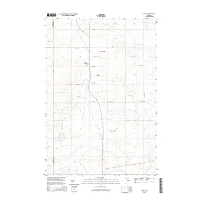
2014 Map of Sagola
USGS Topo · Published 2014About this map
The settlement of Sagola serves as a central hub in this section of the Upper Peninsula, situated at the intersection of critical regional transit corridors. The landscape is defined by the complex hydrology of the Sturgeon River system, including the W Br Sturgeon River, the N Br Sturgeon River, and the West Branch Sturgeon River. This network of waterways, along with the Ford River in the north, historically shaped the logging and development patterns of Dickinson County. The map reveals a high density of glacial lakes and ponds, such as Tamarack Lake, Section Nine Lake, and Section Eleven Lake, interspersed with local routes like Wells Grade Rd and Kramer Rd. To the west, the Iron Co Dickinson Co boundary line marks the transition into the neighboring county, while family-named roads like Bice Creek Ln and Leeman Rd hint at the local land ownership and rural heritage of the township.
Find a feature on this map
35 named features on this map. Tap any name to fly to it.
Don’t see what you’re looking for? This feature index may not catch every label — zoom into the map to look around manually.
Map Details
Editions of this 2014 Sagola Map
This is the sole edition of this map. No revisions or reprints were ever made.
Other maps of this area

1899 · Sagola
USGS Topo · 1:62,500

1939 · Iron Mountain
USGS Topo · 1:48,000

1941 · Iron Mountain
USGS Topo · 1:48,000

1947 · Iron Mountain
USGS Topo · 1:48,000

1947 · Kiernan
USGS Topo · 1:24,000

1947 · Lake Mary
USGS Topo · 1:24,000
1949 · Commonwealth
USGS Topo · 1:24,000

1954 · Iron Mountain
USGS Topo · 1:250,000

1954 · Escanaba
USGS Topo · 1:250,000

1955 · Ralph NW
USGS Topo · 1:24,000