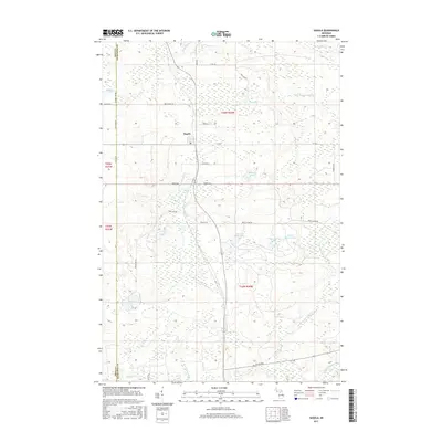
2017 Map of Sagola
USGS Topo · Published 2017About this map
The settlement of Sagola sits at the heart of this Dickinson County landscape, situated where local roads converge amidst a complex network of Upper Peninsula waterways. The drainage patterns here are defined by the Ford River in the northeast and the winding courses of the N Br Sturgeon River and W Br Sturgeon River, which carve through the terrain. The map reveals a high density of glacial lakes and ponds, many named for their public land survey locations, such as Section Nine Lake and Section Eleven Lake.
Find a feature on this map
37 named features on this map. Tap any name to fly to it.
Don’t see what you’re looking for? This feature index may not catch every label — zoom into the map to look around manually.
Map Details
Editions of this 2017 Sagola Map
This is the sole edition of this map. No revisions or reprints were ever made.
Other maps of this area

1899 · Sagola
USGS Topo · 1:62,500

1939 · Iron Mountain
USGS Topo · 1:48,000

1941 · Iron Mountain
USGS Topo · 1:48,000

1947 · Iron Mountain
USGS Topo · 1:48,000

1947 · Kiernan
USGS Topo · 1:24,000

1947 · Lake Mary
USGS Topo · 1:24,000
1949 · Commonwealth
USGS Topo · 1:24,000

1954 · Iron Mountain
USGS Topo · 1:250,000

1954 · Escanaba
USGS Topo · 1:250,000

1955 · Ralph NW
USGS Topo · 1:24,000