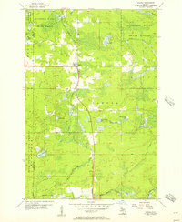
1956 Map of Sagola
USGS Topo · Published 1957About this map
Sagola serves as the primary hub of activity in this northern Michigan timber and rail landscape, situated at the junction of several critical water systems. The Chicago Milwaukee St Paul and Pacific railroad cuts a north-south line through the center of the township, providing a vital artery for the region's mid-century logging and transport economy. The surrounding environment is defined by extensive public lands, including the Iron Range State Forest and Sturgeon River State Forest, which dominate the western and northern sectors of the map.
Find a feature on this map
20 named features on this map. Tap any name to fly to it.
Don’t see what you’re looking for? This feature index may not catch every label — zoom into the map to look around manually.
Map Details
Editions of this 1956 Sagola Map
This is the sole edition of this map. No revisions or reprints were ever made.
Other maps of this area

1899 · Sagola
USGS Topo · 1:62,500

1939 · Iron Mountain
USGS Topo · 1:48,000

1941 · Iron Mountain
USGS Topo · 1:48,000

1947 · Iron Mountain
USGS Topo · 1:48,000

1947 · Kiernan
USGS Topo · 1:24,000

1947 · Lake Mary
USGS Topo · 1:24,000
1949 · Commonwealth
USGS Topo · 1:24,000

1954 · Iron Mountain
USGS Topo · 1:250,000

1954 · Escanaba
USGS Topo · 1:250,000

1955 · Ralph NW
USGS Topo · 1:24,000