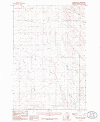
1986 Map of Sahara Hill SW
USGS Topo · Published 1986About this map
The arid high plains of Golden Valley County are defined by seasonal drainages and essential water sources in this mid-1980s provisional survey. Natural features like Merrills Spring Creek and Currant Creek cut through the terrain, while numerous springs provide the lifeblood for ranching operations. The presence of a Corral and a Gravel Pit indicates the practical land use of the era, balancing livestock management with local infrastructure needs. The landscape is also marked by an industrial footprint, most notably a Pipeline that traverses the northern sections. In the northeast, Twin Coulee and Ashley Coulee carve out distinct geological depressions, illustrating the slow erosion patterns of the Montana prairie before modern developments altered these drainage basins.
Find a feature on this map
8 named features on this map. Tap any name to fly to it.
Don’t see what you’re looking for? This feature index may not catch every label — zoom into the map to look around manually.
Map Details
Editions of this 1986 Sahara Hill SW Map
This is the sole edition of this map. No revisions or reprints were ever made.
Other maps of this area

1889 · Big Snowy Mountain
USGS Topo · 1:250,000

1893 · Big Snowy Mountain
USGS Topo · 1:250,000

1954 · Roundup
USGS Topo · 1:250,000

1958 · Roundup
USGS Topo · 1:250,000

1986 · Patterson Canyon
USGS Topo · 1:24,000

1986 · Wallum
USGS Topo · 1:24,000

1986 · Cushman NW
USGS Topo · 1:24,000
1986 · Rothiemay
USGS Topo · 1:24,000
1986 · Cushman NE
USGS Topo · 1:24,000
1986 · Sahara Hill
USGS Topo · 1:24,000