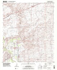
1996 Map of Saint David
USGS Topo · Published 2002About this map
The San Pedro River flows through the heart of the San Pedro Valley, anchoring the settlement of Saint David. This 1996 update, based on aerial imagery and field surveys dating back to the early 1970s, illustrates a landscape defined by water and transit. The Southern Pacific railroad corridor and the Old Railroad Grade trace the historic movement of goods and people across the high desert, while the Sibyl Interchange and Sibyl Road highlight the region's evolving infrastructure. Around Saint David, land use is concentrated near the river, where a High Sch, a Mobile Home Park, and numerous Wells and Water Tanks signify a established community. Farther afield, name labels like Fenner, Adamson, and Sibyl mark smaller nodes of settlement along the rail lines and canyon washes, including Sheep Wash and Dragoon Wash.
Find a feature on this map
27 named features on this map. Tap any name to fly to it.
Don’t see what you’re looking for? This feature index may not catch every label — zoom into the map to look around manually.
Map Details
Editions of this 1996 Saint David Map
This is the sole edition of this map. No revisions or reprints were ever made.
Other maps of this area

1915 · Benson
USGS Topo · 1:125,000

1922 · St. David
USGS Topo · 1:62,500

1926 · Whetstone
USGS Topo · 1:62,500

1943 · Benson
USGS Topo · 1:125,000

1943 · Dragoon
USGS Topo · 1:62,500

1945 · Happy Valley
USGS Topo · 1:62,500

1956 · Nogales
USGS Topo · 1:250,000

1956 · Tucson
USGS Topo · 1:250,000

1958 · Nogales
USGS Topo · 1:250,000

1958 · Tucson
USGS Topo · 1:250,000