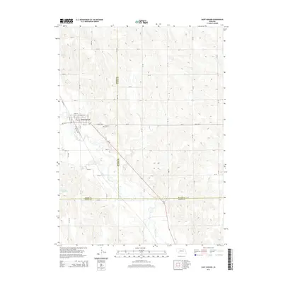
2014 Map of Saint Edward
USGS Topo · Published 2014About this map
Saint Edward serves as the focal point of this 2014 survey, situated where the undulating terrain of the Nebraska plains meets the winding course of Beaver Creek. The town's grid is clearly defined by historical thoroughfares like Water St and Hardy St, with Railroad Ave tracing the legacy of the local rail corridor. Outside the town limits, the landscape is organized into the characteristic section-line road network of the Midwest, including Central Hwy and numerous numbered routes like 305th St and 370th St. To the east of the settlement, Evergreen Cem provides a point of genealogical interest. The surrounding countryside is marked by water features including Bogus Cr and the Jasa Reservoir, illustrating the region's managed water resources for agriculture. Tri-county boundaries for Boone, Platte, and Nance counties converge here, marking this as a significant jurisdictional corner.
Find a feature on this map
32 named features on this map. Tap any name to fly to it.
Don’t see what you’re looking for? This feature index may not catch every label — zoom into the map to look around manually.
Map Details
Editions of this 2014 Saint Edward Map
This is the sole edition of this map. No revisions or reprints were ever made.
Other maps of this area

1896 · Stromsburg
USGS Topo · 1:125,000

1955 · Fremont
USGS Topo · 1:250,000

1957 · Fremont
USGS Topo · 1:250,000

1958 · Fremont
USGS Topo · 1:250,000

1958 · Genoa
USGS Topo · 1:24,000
1958 · Merchiston
USGS Topo · 1:24,000

1958 · Fullerton NE
USGS Topo · 1:24,000

1958 · St. Edward
USGS Topo · 1:24,000

1958 · Albion East
USGS Topo · 1:24,000
1958 · St. Edward SW
USGS Topo · 1:24,000