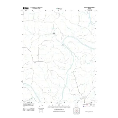
2011 Map of Saint Elizabeth
USGS Topo · Published 2011About this map
The Osage River carves a winding path through this portion of Miller County, defining the local geography around the rural settlements of Saint Elizabeth and Marys Home. At this point in the early 21st century, the landscape is a network of small watercourses like Little Tavern Creek and Cub Creek that feed into the main river channel. Local history and family lineages are anchored at Jenkins Cemetery and the village of Henley, which sits near Henley Lake. The map details a transition from river-bottom land, including Jones Island, to the higher ground connected by historic routes such as Capps Ferry Rd and Old 10 Mile Rd. This survey documents the persistent rural character of the region, where naming conventions like Lousy Creek and Turkey Creek reflect a long-standing relationship with the Missouri backcountry.
Find a feature on this map
50 named features on this map. Tap any name to fly to it.
Don’t see what you’re looking for? This feature index may not catch every label — zoom into the map to look around manually.
Map Details
Editions of this 2011 Saint Elizabeth Map
This is the sole edition of this map. No revisions or reprints were ever made.
Other maps of this area

1888 · Tuscumbia
USGS Topo · 1:125,000

1894 · Tuscumbia
USGS Topo · 1:125,000

1933 · Iberia
USGS Topo · 1:62,500

1937 · Iberia
USGS Topo · 1:62,500

1947 · Jefferson City
USGS Topo · 1:250,000

1948 · Meta
USGS Topo · 1:62,500
1948 · Eugene
USGS Topo · 1:62,500

1948 · Tavern
USGS Topo · 1:62,500
1950 · Meta
USGS Topo · 1:62,500
1950 · Tavern
USGS Topo · 1:62,500