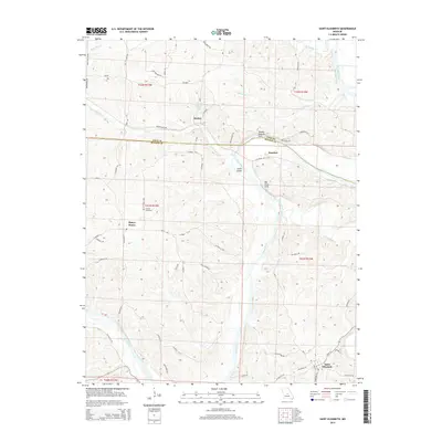
2015 Map of Saint Elizabeth
USGS Topo · Published 2015About this map
Saint Elizabeth anchor the southeastern corner of this Missouri landscape, situated near the winding Osage River. The river corridor dominates the central terrain, featuring distinctive geological landmarks such as Henley Natural Arch and Bat Cave Arch, along with Jones Island positioned at a bend in the water. Smaller settlements like Marys Home and Henley define the rural character of the uplands, connected by a network of county roads and family-named routes such as Capps Ferry Rd. The map illustrates a classic Ozark transition zone where steep drainage basins like Little Tavern Cr and Bois Brule Cr carve through the plateau. For genealogists, the placement of the Jenkins Cemetery and established farmsteads along routes like Bauman Ln and Swift Rd provides clear evidence of long-standing community ties in this river-valley region.
Find a feature on this map
62 named features on this map. Tap any name to fly to it.
Don’t see what you’re looking for? This feature index may not catch every label — zoom into the map to look around manually.
Map Details
Editions of this 2015 Saint Elizabeth Map
This is the sole edition of this map. No revisions or reprints were ever made.
Other maps of this area

1888 · Tuscumbia
USGS Topo · 1:125,000

1894 · Tuscumbia
USGS Topo · 1:125,000

1933 · Iberia
USGS Topo · 1:62,500

1937 · Iberia
USGS Topo · 1:62,500

1947 · Jefferson City
USGS Topo · 1:250,000

1948 · Meta
USGS Topo · 1:62,500
1948 · Eugene
USGS Topo · 1:62,500

1948 · Tavern
USGS Topo · 1:62,500
1950 · Meta
USGS Topo · 1:62,500
1950 · Tavern
USGS Topo · 1:62,500