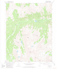
1982 Map of Saint Elmo
USGS Topo · Published 1983About this map
St Elmo and the surrounding high-altitude mining districts within the San Isabel National Forest are captured here as they appeared in the early 1980s. The settlement pattern follows the drainage of Chalk Creek and its various forks, where historic mining centers like Romley and Hancock are linked by a network of steep jeep trails and old pack routes. The landscape is punctuated by significant industrial relics, most notably the Mary Murphy Mine and the Iron Chest Mine, which sit high on the slopes of Chrysolite Mountain. This topographical record documents the spatial relationship between these legacy camps and the water sources that sustained them, such as Alpine Reservoir and Grizzly Lake. From the small Cem near Iron City to the high summits of Tabeguache Peak and Mount Mamma, the map illustrates a terrain defined by 19th-century extraction and late 20th-century recreation.
Find a feature on this map
44 named features on this map. Tap any name to fly to it.
Don’t see what you’re looking for? This feature index may not catch every label — zoom into the map to look around manually.
Map Details
Editions of this 1982 Saint Elmo Map
2 editions found
Other maps of this area

1940 · Garfield
USGS Topo · 1:62,500

1945 · Garfield
USGS Topo · 1:62,500

1955 · Buena Vista
USGS Topo · 1:62,500

1955 · Mount Harvard
USGS Topo · 1:62,500

1956 · Poncha Springs
USGS Topo · 1:62,500

1956 · Montrose
USGS Topo · 1:250,000

1959 · Montrose
USGS Topo · 1:250,000

1960 · Montrose
USGS Topo · 1:250,000

1968 · Montrose
USGS Topo · 1:250,000

1982 · Buena Vista West
USGS Topo · 1:24,000