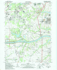
1993 Map of Saint Georges
USGS Topo · Published 1993About this map
The Chesapeake and Delaware Canal dominates the southern landscape of New Castle County, serving as a massive industrial artery flanked by a complex system of levees. The early 1990s character of the region is defined by a transition from traditional agricultural tracts like Crystal Run Farm and Meadowbrook Farms to suburban developments such as Wrangle Hill Estates and Caravel Farms. Near the settlement of Saint Georges, the landscape reveals heavy industrial activity including a refinery and several industrial waste ponds, contrasting with the preserved woodlands of Lums Pond State Park and Red Lion State Forest. Local genealogy and community history are anchored by institutions like McDonough Sch, St Mary Ch, and several burying grounds including Hickory Grove Cem and Asbury Cem.
Find a feature on this map
79 named features on this map. Tap any name to fly to it.
Don’t see what you’re looking for? This feature index may not catch every label — zoom into the map to look around manually.
Map Details
Editions of this 1993 Saint Georges Map
This is the sole edition of this map. No revisions or reprints were ever made.
Other maps of this area

1898 · Elkton
USGS Topo · 1:62,500

1899 · Dover
USGS Topo · 1:125,000

1900 · Elkton
USGS Topo · 1:62,500

1900 · Cecilton
USGS Topo · 1:62,500

1904 · Wilmington
USGS Topo · 1:62,500

1906 · Dover
USGS Topo · 1:125,000

1906 · Wilmington
USGS Topo · 1:62,500

1917 · Elkton
USGS Topo · 1:62,500

1919 · Wilmington
USGS Topo · 1:62,500

1920 · Dover
USGS Topo · 1:125,000