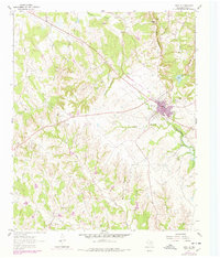
1961 Map of Saint Jo
USGS Topo · Published 1978About this map
Saint Jo serves as the central hub in this survey of Montague County, situated at the crossroads of early North Texas travel. The landscape is defined by the headwaters of the Elm Fork Trinity River and several significant drainages like Clear Creek and Farmers Creek. Geologically, the area transitions from the prominent heights of Gordon Mountain and the ridge known as Devils Backbone into the creek-carved lowlands where numerous quarries indicate the local extractive industry of the mid-20th century.
Find a feature on this map
19 named features on this map. Tap any name to fly to it.
Don’t see what you’re looking for? This feature index may not catch every label — zoom into the map to look around manually.
Map Details
Editions of this 1961 Saint Jo Map
2 editions found
Other maps of this area

1902 · Gainesville
USGS Topo · 1:125,000

1905 · Montague
USGS Topo · 1:125,000

1943 · Gainesville
USGS Topo · 1:125,000

1954 · Sherman
USGS Topo · 1:250,000

1958 · Sherman
USGS Topo · 1:250,000

1961 · Muenster West
USGS Topo · 1:24,000

1961 · Saint Jo
USGS Topo · 1:24,000

1961 · Salona
USGS Topo · 1:24,000

1961 · Freemound
USGS Topo · 1:24,000

1961 · Montague
USGS Topo · 1:24,000