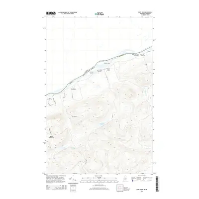
2014 Map of Saint John
USGS Topo · Published 2014About this map
The Upper Saint John River Valley forms a significant international boundary here, separating Aroostook County, Maine, from Canada. This river corridor is the lifeblood of the region, where the Saint John River meanders past Caton Island and Hunnewell Island. In the early 21st century, the settlement pattern remains focused along Main St and St John Rd, where the communities of Saint John and Bradbury serve as local anchors. Family and community heritage is centered at the Saint John Baptist Church Cem and Saint John Catholic Cem. South of the river, the landscape rises into dense woodlands and highland waters such as Hunnewell Lake and Bran Lake. The interior is accessible via rural tracks like Pelletier Lakes Rd, leading toward the Back Settlement, reflecting the region's enduring connection to the timberlands and remote homesteads of northern Maine.
Find a feature on this map
32 named features on this map. Tap any name to fly to it.
Don’t see what you’re looking for? This feature index may not catch every label — zoom into the map to look around manually.
Map Details
Editions of this 2014 Saint John Map
This is the sole edition of this map. No revisions or reprints were ever made.
Other maps of this area

1928 · Eagle Lake
USGS Topo · 1:48,000

1930 · St Francis
USGS Topo · 1:48,000

1931 · Eagle Lake
USGS Topo · 1:62,500

1932 · Fort Kent
USGS Topo · 1:48,000

1933 · St Francis
USGS Topo · 1:62,500

1935 · Fort Kent
USGS Topo · 1:62,500

1962 · Edmundston
USGS Topo · 1:250,000
1975 · St Francis SW
USGS Topo · 1:24,000
1975 · St Francis NW
USGS Topo · 1:24,000
1975 · St Francis SE
USGS Topo · 1:24,000