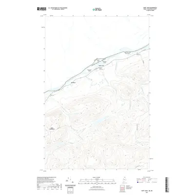
2021 Map of Saint John
USGS Topo · Published 2021About this map
The Upper Saint John River Valley forms the international boundary between Maine and Canada, defined here by the winding course of the Saint John River. This border landscape is dotted with several islands, including Caton Island, Wheelock Island, and Hunnewell Island, which sit just offshore from the riverside settlements of Saint John and Bradbury. Local life is anchored by several spiritual and burial sites, notably the Saint John Baptist Church Cem and Saint John Catholic Cem, reflecting the cultural heritage of this northern frontier.
Find a feature on this map
27 named features on this map. Tap any name to fly to it.
Don’t see what you’re looking for? This feature index may not catch every label — zoom into the map to look around manually.
Map Details
Editions of this 2021 Saint John Map
This is the sole edition of this map. No revisions or reprints were ever made.
Other maps of this area

1928 · Eagle Lake
USGS Topo · 1:48,000

1930 · St Francis
USGS Topo · 1:48,000

1931 · Eagle Lake
USGS Topo · 1:62,500

1932 · Fort Kent
USGS Topo · 1:48,000

1933 · St Francis
USGS Topo · 1:62,500

1935 · Fort Kent
USGS Topo · 1:62,500

1962 · Edmundston
USGS Topo · 1:250,000
1975 · St Francis SW
USGS Topo · 1:24,000
1975 · St Francis NW
USGS Topo · 1:24,000
1975 · St Francis SE
USGS Topo · 1:24,000