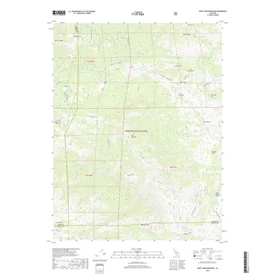
2018 Map of Saint John Mountain
USGS Topo · Published 2018About this map
Saint John Mtn and the surrounding high-altitude terrain of the Mendocino National Forest define this landscape at the intersection of Colusa, Glenn, and Lake Counties. The map reveals a complex network of seasonal drainages and springs, including Middle Fork Stony Cr, Briscoe Cr, and Sheetiron Spring, which have shaped the movement through these ridges for generations. Smaller settlements and designated locales like Bonnie View, Red Rock, and Low Gap provide points of reference within a landscape largely dominated by significant geographical features such as Felkner Ridge and Black Diamond Ridge. The inclusion of named fire roads and trails, such as Ponderosa Way and Open Ridge-Black Diamond, highlights the modern management of these wooded lands while preserving the traditional place-names used by local inhabitants and early surveyors.
Find a feature on this map
46 named features on this map. Tap any name to fly to it.
Don’t see what you’re looking for? This feature index may not catch every label — zoom into the map to look around manually.
Map Details
Editions of this 2018 Saint John Mountain Map
This is the sole edition of this map. No revisions or reprints were ever made.
Other maps of this area

1919 · Elk Creek
USGS Topo · 1:62,500

1922 · Hullville
USGS Topo · 1:62,500

1948 · Elk Creek
USGS Topo · 1:62,500

1951 · Lake Pillsbury
USGS Topo · 1:62,500

1951 · Stonyford
USGS Topo · 1:62,500

1952 · Hull Mountain
USGS Topo · 1:62,500

1957 · Elk Creek
USGS Topo · 1:62,500

1957 · Ukiah
USGS Topo · 1:250,000

1960 · Ukiah
USGS Topo · 1:250,000
1967 · Potato Hill
USGS Topo · 1:24,000