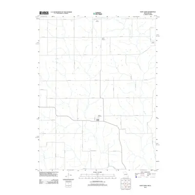
2012 Map of Saint John
USGS Topo · Published 2012About this map
The unincorporated community of Saint John sits at the heart of this Missouri-Iowa border landscape, where the rural grid of Putnam County meets the northern drainages of the West Fork Locust Creek and Locust Creek. This survey captures the agricultural character of the early 21st century, defined by a network of county roads like Davis Rd and Birch Rd that connect isolated family landmarks and burial grounds. Genealogists will find several significant sites, including Harris Cemetery, Pleasant View Cemetery, Genoa Cemetery, and Torrey Cemetery, which serve as physical markers of the area's long-standing settlement history. Water management is evident near the center of the map at the Seaton Lake Dam, while the meandering course of Elm Branch cuts through the southwestern corner, illustrating the local topography that dictated farm placement and road routes through this borderland region.
Find a feature on this map
26 named features on this map. Tap any name to fly to it.
Don’t see what you’re looking for? This feature index may not catch every label — zoom into the map to look around manually.
Map Details
Editions of this 2012 Saint John Map
This is the sole edition of this map. No revisions or reprints were ever made.
Other maps of this area

1942 · Seymour
USGS Topo · 1:62,500

1944 · Seymour
USGS Topo · 1:62,500

1954 · Centerville
USGS Topo · 1:250,000

1957 · Centerville
USGS Topo · 1:250,000

1958 · Centerville
USGS Topo · 1:250,000

1964 · Pollock NW
USGS Topo · 1:24,000

1964 · Unionville West
USGS Topo · 1:24,000

1964 · Lucerne
USGS Topo · 1:24,000

1964 · Allerton
USGS Topo · 1:24,000
1964 · Powersville
USGS Topo · 1:24,000