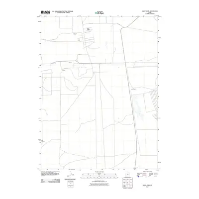
2011 Map of Saint John
USGS Topo · Published 2011About this map
Rush Valley and the neighboring settlements of Saint John and Clover form a distinct rural cluster in this 2011 survey of Tooele County. The area is defined by a grid of local roads and the seasonal flow of Clover Creek as it winds past the Clover Cemetery and toward Clover Station. This map captures the region's agricultural layout, where residential clusters are situated near the historic Saint John Cemetery and transition into the more open terrain leading toward Big Canyon. South of these primary settlements, the landscape opens further toward the small community of Center and the drainage of Faust Creek. The documentation of family burial sites and specific road names like Charles Hill Rd and Meadow Ln provides a precise view of the valley's modern geography while preserving the locations of its long-standing pioneer-era anchors.
Find a feature on this map
22 named features on this map. Tap any name to fly to it.
Don’t see what you’re looking for? This feature index may not catch every label — zoom into the map to look around manually.
Map Details
Editions of this 2011 Saint John Map
This is the sole edition of this map. No revisions or reprints were ever made.
Other maps of this area

1885 · Tooele Valley
USGS Topo · 1:250,000

1918 · Stockton
USGS Topo · 1:62,500

1953 · Tooele
USGS Topo · 1:250,000

1955 · Deseret Peak
USGS Topo · 1:62,500

1955 · Stockton
USGS Topo · 1:62,500

1955 · Tooele
USGS Topo · 1:250,000
1971 · Vernon NE
USGS Topo · 1:24,000
1971 · Faust
USGS Topo · 1:24,000

1971 · Onaqui Mts South
USGS Topo · 1:24,000

1979 · Rush Valley
USGS Topo · 1:100,000