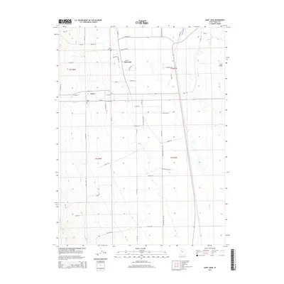
2014 Map of Saint John
USGS Topo · Published 2014About this map
Rush Valley provides a high-desert backdrop for the small settlements of Saint John and Clover, two historic agricultural communities in eastern Tooele County. The landscape is defined by the intersection of traditional livestock grazing and modern infrastructure, visible where the Pacific Rail Rd cuts through the eastern valley floor. Water remains the primary shaper of human activity here, with Clover Cr and Faust Cr draining the nearby uplands and feeding the fields surrounding the town centers. Genealogists and local historians can trace the community's roots at the Saint John Cem and Clover Cem, while the grid of family-named roads like Thompson Ln and S Johnson Ln reveals the long-standing land divisions that have persisted into the 21st century.
Find a feature on this map
52 named features on this map. Tap any name to fly to it.
Don’t see what you’re looking for? This feature index may not catch every label — zoom into the map to look around manually.
Map Details
Editions of this 2014 Saint John Map
This is the sole edition of this map. No revisions or reprints were ever made.
Other maps of this area

1885 · Tooele Valley
USGS Topo · 1:250,000

1918 · Stockton
USGS Topo · 1:62,500

1953 · Tooele
USGS Topo · 1:250,000

1955 · Deseret Peak
USGS Topo · 1:62,500

1955 · Stockton
USGS Topo · 1:62,500

1955 · Tooele
USGS Topo · 1:250,000
1971 · Vernon NE
USGS Topo · 1:24,000
1971 · Faust
USGS Topo · 1:24,000

1971 · Onaqui Mts South
USGS Topo · 1:24,000

1979 · Rush Valley
USGS Topo · 1:100,000