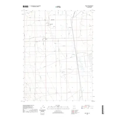
2020 Map of Saint John
USGS Topo · Published 2020About this map
Saint John and Clover anchor this corner of the Tooele County high desert, situated within the broad expanse of Rush Valley. The landscape is defined by its rectilinear grid of agricultural and ranching corridors, including Mormon Trail Rd and Indian Mtn Rd, which navigate the arid basin. Water management is central to life here, as seen in the seasonal courses of Clover Cr and Faust Cr that descend from the surrounding highlands toward the valley floor. The local community structure is anchored by family and faith, evidenced by the Saint John Cem and Clover Cem located near the town centers. The eastern edge of the map features the Pacific Railrd corridor, a vital transportation artery that skirts the valley, illustrating the historical reliance on rail for connecting these high-altitude rural settlements to the broader regional economy.
Find a feature on this map
48 named features on this map. Tap any name to fly to it.
Don’t see what you’re looking for? This feature index may not catch every label — zoom into the map to look around manually.
Map Details
Editions of this 2020 Saint John Map
This is the sole edition of this map. No revisions or reprints were ever made.
Other maps of this area

1885 · Tooele Valley
USGS Topo · 1:250,000

1918 · Stockton
USGS Topo · 1:62,500

1953 · Tooele
USGS Topo · 1:250,000

1955 · Deseret Peak
USGS Topo · 1:62,500

1955 · Stockton
USGS Topo · 1:62,500

1955 · Tooele
USGS Topo · 1:250,000
1971 · Vernon NE
USGS Topo · 1:24,000
1971 · Faust
USGS Topo · 1:24,000

1971 · Onaqui Mts South
USGS Topo · 1:24,000

1979 · Rush Valley
USGS Topo · 1:100,000