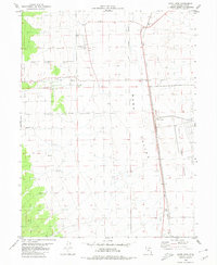
1980 Map of Saint John
USGS Topo · Published 1980About this map
Rush Valley dominates this 1980 survey, where the agricultural life of Clover and Saint John meets the industrial and military infrastructure of western Utah. The landscape is defined by the reliable passage of the Union Pacific railroad, which services several points including Saint John Sta, Clover Siding, and the small settlement of Ajax to the south.
Find a feature on this map
16 named features on this map. Tap any name to fly to it.
Don’t see what you’re looking for? This feature index may not catch every label — zoom into the map to look around manually.
Map Details
Editions of this 1980 Saint John Map
This is the sole edition of this map. No revisions or reprints were ever made.
Other maps of this area

1885 · Tooele Valley
USGS Topo · 1:250,000

1918 · Stockton
USGS Topo · 1:62,500

1953 · Tooele
USGS Topo · 1:250,000

1955 · Deseret Peak
USGS Topo · 1:62,500

1955 · Stockton
USGS Topo · 1:62,500

1955 · Tooele
USGS Topo · 1:250,000
1971 · Vernon NE
USGS Topo · 1:24,000
1971 · Faust
USGS Topo · 1:24,000

1971 · Onaqui Mts South
USGS Topo · 1:24,000

1979 · Rush Valley
USGS Topo · 1:100,000