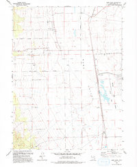
1993 Map of Saint John
USGS Topo · Published 1993About this map
Saint John and Clover anchor this portion of the Rush Valley, where the intersection of agricultural settlements and military expansion is clearly visible. The landscape is defined by the drainage of Clover Creek and various springs, supporting small-scale ranching and farming in the shadow of the mountains. Toward the east, the sprawling footprint of the Tooele Army Depot (South Area) introduces a massive industrial and storage complex that contrasts with the rural character of the neighboring towns. Transportation networks are well-established, with rail infrastructure including Saint John Sta and the Clover Siding facilitating the movement of goods and military materiel. Local resource extraction is evidenced by several Drill Holes, a Gravel Pit, and a Borrow Pit, indicating the ongoing utility of the valley's geological deposits during the late twentieth century.
Find a feature on this map
17 named features on this map. Tap any name to fly to it.
Don’t see what you’re looking for? This feature index may not catch every label — zoom into the map to look around manually.
Map Details
Editions of this 1993 Saint John Map
This is the sole edition of this map. No revisions or reprints were ever made.
Other maps of this area

1885 · Tooele Valley
USGS Topo · 1:250,000

1918 · Stockton
USGS Topo · 1:62,500

1953 · Tooele
USGS Topo · 1:250,000

1955 · Deseret Peak
USGS Topo · 1:62,500

1955 · Stockton
USGS Topo · 1:62,500

1955 · Tooele
USGS Topo · 1:250,000
1971 · Vernon NE
USGS Topo · 1:24,000
1971 · Faust
USGS Topo · 1:24,000

1971 · Onaqui Mts South
USGS Topo · 1:24,000

1979 · Rush Valley
USGS Topo · 1:100,000