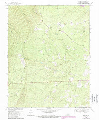
1968 Map of Saint Joy
USGS Topo · Published 1987About this map
The community of Saint Joy serves as a focal point for this landscape in Buckingham County, where small rural settlements are tied together by a network of winding creeks and family-named landmarks. The terrain is defined by the drainage systems of the North River and its numerous tributaries, including Bishop Creek, Sawmill Creek, and Austin Creek. This 1960s survey, with updates from the 1980s, reveals a high concentration of religious and community centers that speak to the area's social fabric, such as Mount Tabor Ch, Gladstone Ch, and Antioch Ch. Many of these churches are paired with local cemeteries, providing essential data for genealogists tracing family histories in the region. The map also documents specific water features like Ragland Lake and the unusually named Brick Kiln Branch, suggesting historic land uses or small-scale industries that shaped the local economy before the late 20th century.
Find a feature on this map
24 named features on this map. Tap any name to fly to it.
Don’t see what you’re looking for? This feature index may not catch every label — zoom into the map to look around manually.
Map Details
Editions of this 1968 Saint Joy Map
2 editions found
Other maps of this area

1892 · Buckingham
USGS Topo · 1:125,000

1892 · Appomattox
USGS Topo · 1:125,000

1947 · Roanoke
USGS Topo · 1:250,000

1958 · Appomattox
USGS Topo · 1:62,500

1958 · Pamplin City
USGS Topo · 1:62,500

1959 · Roanoke
USGS Topo · 1:250,000

1961 · Shipman
USGS Topo · 1:62,500

1961 · Buckingham
USGS Topo · 1:62,500

1963 · Roanoke
USGS Topo · 1:250,000

1967 · Andersonville
USGS Topo · 1:24,000