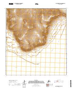
2020 Map of Saint Lawrence B-0 SW
USGS Topo · Published 2020About this map
Kinipaghulghat Mountains dominate the northern portion of this coastal survey, where steep terrain transitions sharply toward the Bering Sea. The landscape is characterized by its isolation on Saint Lawrence Island, with the southern coastline defined by the prominent Apavawook Cape. This 2020 edition provides a precise look at the topographical contours of the island's southern edge, capturing the relationship between the elevated mountain range and the sea. The lack of modern road infrastructure underscores the wilderness character of the region, emphasizing natural landmarks over human development. Researchers will find the land survey boundaries, including t26s r54w and t27s r54w, useful for orienting the remote coastal features within the broader Alaskan census area.
Find a feature on this map
7 named features on this map. Tap any name to fly to it.
Don’t see what you’re looking for? This feature index may not catch every label — zoom into the map to look around manually.
Map Details
Editions of this 2020 Saint Lawrence B-0 SW Map
This is the sole edition of this map. No revisions or reprints were ever made.
Other maps of this area

1948 · St Lawrence
USGS Topo · 1:250,000

1949 · St Lawrence
USGS Topo · 1:250,000

1964 · St Lawrence
USGS Topo · 1:250,000
2020 · Saint Lawrence A-0 NW
USGS Topo · 1:25,000
2020 · Saint Lawrence B-0 NE
USGS Topo · 1:25,000
2020 · Saint Lawrence B-1 SE
USGS Topo · 1:25,000
2020 · Saint Lawrence B-0 SE
USGS Topo · 1:25,000
2020 · Saint Lawrence B-0 NW
USGS Topo · 1:25,000
2020 · Saint Lawrence B-1 NE
USGS Topo · 1:25,000