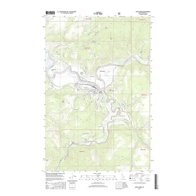
2017 Map of Saint Maries
USGS Topo · Published 2017About this map
The Saint Joe River and Saint Maries River converge at the heart of this North Idaho landscape, defining the layout of Saint Maries and the nearby settlement of Riverdale. This survey documents the complex water system where the rivers meet, featuring numerous oxbows, lakes such as Swan Lake and Porrett Lake, and the turbulent Lykwe Rapid. The town's grid is detailed with street names like Kootenai Ave and Milwaukee Rd, reflecting its proximity to the St Maries Ave corridor.
Find a feature on this map
96 named features on this map. Tap any name to fly to it.
Don’t see what you’re looking for? This feature index may not catch every label — zoom into the map to look around manually.
Map Details
Editions of this 2017 Saint Maries Map
This is the sole edition of this map. No revisions or reprints were ever made.
Other maps of this area

1950 · Rochat Peak
USGS Topo · 1:24,000

1952 · Rochat Peak
USGS Topo · 1:24,000

1955 · Spokane
USGS Topo · 1:250,000

1957 · St. Maries
USGS Topo · 1:62,500

1957 · Emida
USGS Topo · 1:62,500

1957 · St. Joe
USGS Topo · 1:62,500

1958 · Spokane
USGS Topo · 1:250,000

1961 · Fernwood
USGS Topo · 1:62,500

1981 · St Maries
USGS Topo · 1:100,000
1981 · Medimont
USGS Topo · 1:24,000