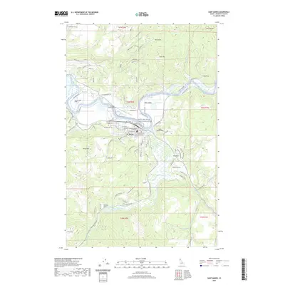
2020 Map of Saint Maries
USGS Topo · Published 2020About this map
The confluence of the Saint Maries River and the Saint Joe Wild and Scenic River centers this 2020 topographic study of Benewah County. The city of St. Maries serves as a focal point, showing the established grid of Main Avenue and Center Avenue near the Benewah County Courthouse. To the west, the St Maries Municipal Airport and Woodlawn Cem are key landmarks of the local infrastructure. The landscape is defined by its diverse hydrography, including the Loe'ykwu' Rapid and various bodies of water like Swan Lake and Porrett Lake. High points such as Saint Maries Peak, Sharp Top, and Kings Peak surround the river valley, while the northern terrain is dissected by Hells Gulch and Cedar Draw. This modern survey reflects a region where the wild character of the protected river corridor meets the developed county seat.
Find a feature on this map
93 named features on this map. Tap any name to fly to it.
Don’t see what you’re looking for? This feature index may not catch every label — zoom into the map to look around manually.
Map Details
Editions of this 2020 Saint Maries Map
This is the sole edition of this map. No revisions or reprints were ever made.
Other maps of this area

1950 · Rochat Peak
USGS Topo · 1:24,000

1952 · Rochat Peak
USGS Topo · 1:24,000

1955 · Spokane
USGS Topo · 1:250,000

1957 · St. Maries
USGS Topo · 1:62,500

1957 · Emida
USGS Topo · 1:62,500

1957 · St. Joe
USGS Topo · 1:62,500

1958 · Spokane
USGS Topo · 1:250,000

1961 · Fernwood
USGS Topo · 1:62,500

1981 · St Maries
USGS Topo · 1:100,000
1981 · Medimont
USGS Topo · 1:24,000