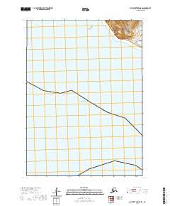
2020 Map of Saint Matthew B-5 SW
USGS Topo · Published 2020About this map
Split Rock stands as the primary landmark on this coastal section of the remote Bering Sea islands, where the land meets the cold waters of the Bering Sea. Located in the Bethel Census Area, this terrain is characterized by steep coastal cliffs and a maritime environment that has long defined the edges of Alaskan territory. The map delineates the precise township and range boundaries of t3n r135w and t2n r135w, marking a stretch of coastline where geographic features are sparse but significant for navigation and historical surveying. The survey captured here records the isolated shoreline before natural erosion and the shifting northern environment alter these coastal profiles.
Find a feature on this map
4 named features on this map. Tap any name to fly to it.
Don’t see what you’re looking for? This feature index may not catch every label — zoom into the map to look around manually.
Map Details
Editions of this 2020 Saint Matthew B-5 SW Map
This is the sole edition of this map. No revisions or reprints were ever made.
Other maps of this area
1951 · St Matthew
USGS Topo · 1:250,000

1969 · St. Matthew
USGS Topo · 1:250,000
2020 · Saint Matthew B-5 SE
USGS Topo · 1:25,000
2020 · Saint Matthew A-5 NW
USGS Topo · 1:25,000
2020 · Saint Matthew B-6 NE
USGS Topo · 1:25,000
2020 · Saint Matthew B-5 NE
USGS Topo · 1:25,000
2020 · Saint Matthew B-5 NW
USGS Topo · 1:25,000