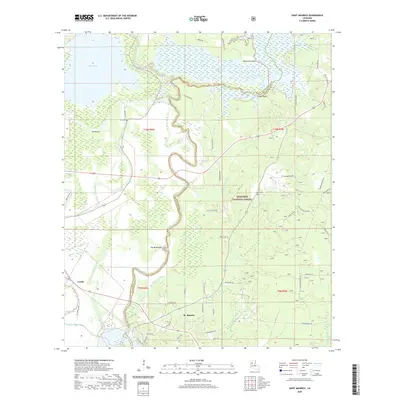
2020 Map of Saint Maurice
USGS Topo · Published 2020About this map
The Red River and Saline Bayou define this section of the Louisiana riverlands, where the boundaries of Natchitoches and Winn Parishes meet. The settlement of St. Maurice sits at a junction of regional routes including Harrisonburg Rd, while Luella marks the western edge of the quadrangle. The landscape is characterized by complex hydrology, with the meandering bayous giving rise to distinctive terrain features like The Horseshoe and The Butte.
Find a feature on this map
70 named features on this map. Tap any name to fly to it.
Don’t see what you’re looking for? This feature index may not catch every label — zoom into the map to look around manually.
Map Details
Editions of this 2020 Saint Maurice Map
This is the sole edition of this map. No revisions or reprints were ever made.
Other maps of this area

1935 · Verda
USGS Topo · 1:31,680

1937 · Campti NE
USGS Topo · 1:31,680

1937 · Bermuda
USGS Topo · 1:31,680

1937 · Campti SE
USGS Topo · 1:31,680

1937 · Montgomery
USGS Topo · 1:62,500

1942 · Montgomery
USGS Topo · 1:62,500

1943 · Provencal
USGS Topo · 1:62,500

1944 · Campti
USGS Topo · 1:62,500

1945 · Montgomery
USGS Topo · 1:62,500

1945 · Provencal
USGS Topo · 1:62,500