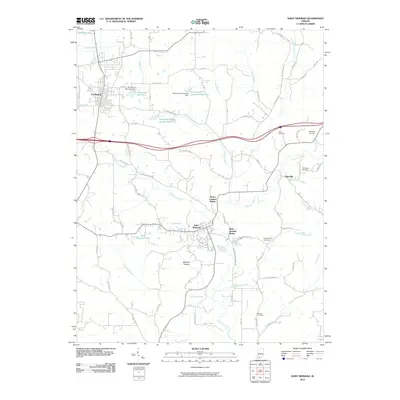
2010 Map of Saint Meinrad
USGS Topo · Published 2010About this map
Ferdinand and Saint Meinrad anchor this 2010 survey of southern Indiana, a landscape defined by significant religious landmarks and a complex network of waterways. The Monte Cassino Shrine and Saint Josephs Shrine stand as notable cultural points of interest, reflecting the area's spiritual heritage. The geography is heavily influenced by the Anderson River and numerous small streams such as Swinging Creek, Crooks Hollow Creek, and Blackhawk Creek.
Find a feature on this map
95 named features on this map. Tap any name to fly to it.
Don’t see what you’re looking for? This feature index may not catch every label — zoom into the map to look around manually.
Map Details
Editions of this 2010 Saint Meinrad Map
This is the sole edition of this map. No revisions or reprints were ever made.
Other maps of this area

1900 · St Meinrad
USGS Topo · 1:62,500

1903 · St. Meinrad
USGS Topo · 1:62,500

1954 · Huntingburg
USGS Topo · 1:24,000

1955 · Saint Anthony
USGS Topo · 1:24,000

1956 · Vincennes
USGS Topo · 1:250,000

1957 · Vincennes
USGS Topo · 1:250,000

1957 · Birdseye
USGS Topo · 1:24,000
1957 · Bristow
USGS Topo · 1:24,000

1958 · Vincennes
USGS Topo · 1:250,000
1958 · Gatchel
USGS Topo · 1:24,000