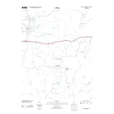
2013 Map of Saint Meinrad
USGS Topo · Published 2013About this map
Saint Meinrad and Ferdinand anchor this portion of southern Indiana, reflecting a landscape deeply influenced by monastic and religious tradition. The presence of the Monte Cassino Shrine and Saint Josephs Shrine highlights the cultural significance of the area, which is situated among the winding drainages of the Anderson River and Hurricane Cr. The local water infrastructure is prominent, with the Ferdinand Water Supply Reservoir, Ferdinand Old Lake, and the Felmont Oil Company Reservoir marking the industrial and municipal development of the region. Topographical features like Meinrad Hollow and various small runs, including Abbey Run and Monkey Hollow Ditch, define the drainage patterns surrounding these communities. The map also captures smaller settlements like Adyeville, connected by a network of rural roads that navigate the complex system of creeks and timbered valleys in the early twenty-first century.
Find a feature on this map
145 named features on this map. Tap any name to fly to it.
Don’t see what you’re looking for? This feature index may not catch every label — zoom into the map to look around manually.
Map Details
Editions of this 2013 Saint Meinrad Map
This is the sole edition of this map. No revisions or reprints were ever made.
Other maps of this area

1900 · St Meinrad
USGS Topo · 1:62,500

1903 · St. Meinrad
USGS Topo · 1:62,500

1954 · Huntingburg
USGS Topo · 1:24,000

1955 · Saint Anthony
USGS Topo · 1:24,000

1956 · Vincennes
USGS Topo · 1:250,000

1957 · Vincennes
USGS Topo · 1:250,000

1957 · Birdseye
USGS Topo · 1:24,000
1957 · Bristow
USGS Topo · 1:24,000

1958 · Vincennes
USGS Topo · 1:250,000
1958 · Gatchel
USGS Topo · 1:24,000