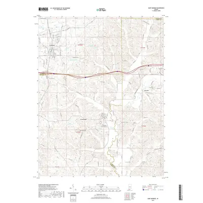
2019 Map of Saint Meinrad
USGS Topo · Published 2019About this map
Saint Meinrad Archabbey anchors the landscape of southern Indiana in this 2019 survey, serving as a prominent landmark near the community of St. Meinrad. The region is defined by its monastic and rural character, with the town of Ferdinand situated to the northwest. Water management is a visible priority for these settlements, evidenced by the Ferdinand Water Supply Reservoir and the Felmont Oil Company Reservoir.
Find a feature on this map
122 named features on this map. Tap any name to fly to it.
Don’t see what you’re looking for? This feature index may not catch every label — zoom into the map to look around manually.
Map Details
Editions of this 2019 Saint Meinrad Map
This is the sole edition of this map. No revisions or reprints were ever made.
Other maps of this area

1900 · St Meinrad
USGS Topo · 1:62,500

1903 · St. Meinrad
USGS Topo · 1:62,500

1954 · Huntingburg
USGS Topo · 1:24,000

1955 · Saint Anthony
USGS Topo · 1:24,000

1956 · Vincennes
USGS Topo · 1:250,000

1957 · Vincennes
USGS Topo · 1:250,000

1957 · Birdseye
USGS Topo · 1:24,000
1957 · Bristow
USGS Topo · 1:24,000

1958 · Vincennes
USGS Topo · 1:250,000
1958 · Gatchel
USGS Topo · 1:24,000