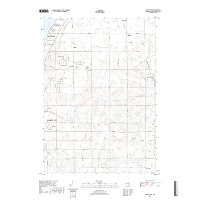
2018 Map of Saint Peter
USGS Topo · Published 2018About this map
Lake Winnebago defines the northwestern shoreline of this Fond du Lac County landscape, where a series of seasonal and residential lakefront communities like Welling Beach, Gladstone Beach, and Linden Beach sit at the base of the glacial terrain. The eastern interior transitions into a high-relief agricultural upland characterized by several small, historically Catholic crossroads settlements. In this 2018 survey, the rural character of the region remains largely intact, anchored by villages such as St. Peter, Silica, and Mount Calvary, the latter home to Holy Cross Cem. Local hydrology is governed by the branching headwaters of three distinct systems: Taycheedah Creek, the South Branch Manitowoc River, and the Sheboygan River. These drainage patterns, combined with features like Mary Hill and the Nett Construction Airport, illustrate a modern landscape still deeply influenced by its underlying geology and mid-19th-century settlement foundations.
Find a feature on this map
91 named features on this map. Tap any name to fly to it.
Don’t see what you’re looking for? This feature index may not catch every label — zoom into the map to look around manually.
Map Details
Editions of this 2018 Saint Peter Map
This is the sole edition of this map. No revisions or reprints were ever made.
Other maps of this area

1910 · Fond du Lac
USGS Topo · 1:62,500

1954 · Kiel
USGS Topo · 1:62,500

1955 · Campbellsport
USGS Topo · 1:62,500

1955 · Kewaskum
USGS Topo · 1:62,500

1955 · Fond Du Lac
USGS Topo · 1:62,500

1955 · Fond Du Lac
USGS Topo · 1:24,000

1957 · Madison
USGS Topo · 1:250,000

1960 · Madison
USGS Topo · 1:250,000

1974 · St. Cloud
USGS Topo · 1:24,000
1974 · Dundee
USGS Topo · 1:24,000