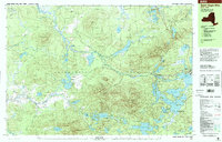
1999 Map of Saint Regis Mtn.
USGS Topo · Published 2001About this map
Adirondack Park dominates this landscape, revealing a dense network of water bodies and high peaks in Franklin County. The topography is defined by the elevation of Saint Regis Mtn and its Lookout Tower, overlooking a complex system of interconnected ponds and lakes that have long shaped the region's character. To the east, the settlement of Paul Smiths and the neighboring Keese Mill serve as the primary hubs of human activity, situated near the shores of Lower Saint Regis Lake. This area, encompassing parts of Santa Clara and Brighton, exhibits a classic wilderness pattern where the Saint Regis River snakes through the lowlands between massifs like Jenkins Mountain and Brandon Hill. The map also captures smaller details of local heritage, such as a Church and Cem near the lakefront, reflecting the established community life amidst the forest and glacial waters of Spitfire Lake and Saint Regis Pond.
Find a feature on this map
63 named features on this map. Tap any name to fly to it.
Don’t see what you’re looking for? This feature index may not catch every label — zoom into the map to look around manually.
Map Details
Editions of this 1999 Saint Regis Mtn. Map
This is the sole edition of this map. No revisions or reprints were ever made.
Other maps of this area

1902 · Saranac
USGS Topo · 1:62,500

1904 · Saranac
USGS Topo · 1:62,500

1905 · Saint Regis
USGS Topo · 1:62,500

1906 · Loon Lake
USGS Topo · 1:62,500

1908 · Loon Lake
USGS Topo · 1:62,500

1919 · Nicholville
USGS Topo · 1:62,500

1920 · Childwold
USGS Topo · 1:62,500

1921 · Childwold
USGS Topo · 1:48,000

1921 · Nicholville
USGS Topo · 1:62,500

1921 · Santa Clara
USGS Topo · 1:62,500