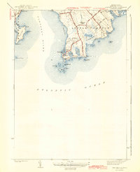
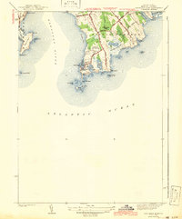
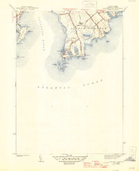
1942 Map of Sakonnet Point
USGS Topo · Published 1942About this map
The rocky promontories and salt ponds of coastal Rhode Island define this 1939 topographic survey. At the southern terminus of the peninsula, Sakonnet Point stands as a focal point for maritime navigation, supported by the Sakonnet Lh and the sheltered waters of Sakonnet Harbor. The interior of Little Compton reveals a landscape transitioning from agricultural holdings to recreational coastal use, marked by the Sakonnet Golf Course and Awashonks Park.
Find a feature on this map
41 named features on this map. Tap any name to fly to it.
Don’t see what you’re looking for? This feature index may not catch every label — zoom into the map to look around manually.
Map Details
Editions of this 1942 Sakonnet Point Map
3 editions found
Other maps of this area

1885 · Sakonnet
USGS Topo · 1:62,500

1888 · Fall River
USGS Topo · 1:62,500

1888 · Sakonnet
USGS Topo · 1:62,500

1889 · Newport
USGS Topo · 1:62,500

1890 · Narragansett Bay
USGS Topo · 1:62,500

1892 · Narragansett Bay
USGS Topo · 1:62,500

1893 · Sakonnet
USGS Topo · 1:62,500

1893 · Fall River
USGS Topo · 1:62,500

1894 · Newport
USGS Topo · 1:62,500

1904 · Newport
USGS Topo · 1:62,500