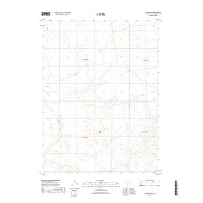
2017 Map of Salazar Butte
USGS Topo · Published 2017About this map
Salazar Butte and the pronounced Willow Creek Rim define this arid landscape in Sweetwater County. The 2017 survey details a network of vital water management features essential for land use in this high desert environment, including Willow Reservoir and Salazar Reservoir. These catchments, along with drainages like Shallow Creek, W Br Willow Cr, and E Br Willow Cr, show how seasonal water is channeled through the terrain. The presence of BLM RD 4411 indicates the infrastructure supporting public land management and access. This map illustrates the intersection of natural topography and human intervention in the Great Divide Basin region, where livestock grazing and resource management rely on these scattered water sources and primitive road networks.
Find a feature on this map
12 named features on this map. Tap any name to fly to it.
Don’t see what you’re looking for? This feature index may not catch every label — zoom into the map to look around manually.
Map Details
Editions of this 2017 Salazar Butte Map
This is the sole edition of this map. No revisions or reprints were ever made.
Other maps of this area

1954 · Rawlins
USGS Topo · 1:250,000

1954 · Rock Springs
USGS Topo · 1:250,000

1958 · Rawlins
USGS Topo · 1:250,000

1958 · Rock Springs
USGS Topo · 1:250,000

1962 · Rawlins
USGS Topo · 1:250,000

1962 · Rock Springs
USGS Topo · 1:250,000

1967 · Rawlins
USGS Topo · 1:250,000

1970 · South Barrel Spring
USGS Topo · 1:24,000

1970 · Prehistoric Rim
USGS Topo · 1:24,000
1970 · Powder Mountain NE
USGS Topo · 1:24,000