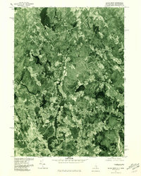
1977 Map of Salem Depot
USGS Topo · Published 1981About this map
Salem Depot and Salem anchor this 1970s orthophotoquad, showing the New Hampshire-Massachusetts borderlands at a time of significant suburban development. Unlike traditional topographic maps, this aerial imagery reveals the exact footprint of housing clusters, commercial centers, and the cleared land of the era. The landscape is defined by its water resources, with the Arlington Mill Reservoir and Canobie Lake serving as central landmarks amidst a mosaic of wooded tracts and expanding neighborhoods. The Merrimack River flows along the southeastern edge, illustrating the historic connection between these upland settlements and the regional river system. To the north and east, more open terrain surrounds Atkinson and Island Pond, capturing the varied density of Rockingham County before further modern expansion. This photographic survey provides researchers with a precise visual baseline for land use, showing the transition from rural woodlots to a structured suburban environment.
Find a feature on this map
9 named features on this map. Tap any name to fly to it.
Don’t see what you’re looking for? This feature index may not catch every label — zoom into the map to look around manually.
Map Details
Editions of this 1977 Salem Depot Map
This is the sole edition of this map. No revisions or reprints were ever made.
Other maps of this area

1886 · Lawrence
USGS Topo · 1:62,500

1886 · Lowell
USGS Topo · 1:62,500

1888 · Haverhill
USGS Topo · 1:62,500

1888 · Lawrence
USGS Topo · 1:62,500

1890 · Haverhill
USGS Topo · 1:62,500

1893 · Lowell
USGS Topo · 1:62,500

1893 · Lawrence
USGS Topo · 1:62,500

1893 · Haverhill
USGS Topo · 1:62,500

1905 · Manchester
USGS Topo · 1:62,500

1918 · Lowell
USGS Topo · 1:62,500