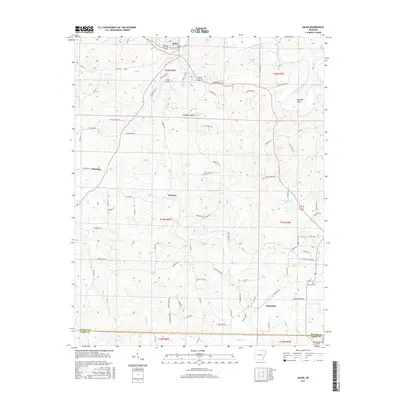
2017 Map of Salem
USGS Topo · Published 2017About this map
Salem serves as the primary hub in this Fulton County landscape, where the northern terrain is defined by the winding course of Town Cr and the proximity of the Salem Airport. The topography transitions south toward the Izard Co line, characterized by a network of drainage basins like Bullpen Cr and Hubble Br. Small rural centers including Wheeling and Fairview are connected by a web of local roads such as Byron RD and Wheeling RD, illustrating a settlement pattern rooted in the upland geography. To the east, the South Fork Spring River carves through the land, creating distinctive features like Pinhook Bend and supporting local water bodies such as Dogget Lake and McCullough Lake. This 2017 survey provides a clear look at the contemporary road network and land divisions within t20n r8w and surrounding townships.
Find a feature on this map
86 named features on this map. Tap any name to fly to it.
Don’t see what you’re looking for? This feature index may not catch every label — zoom into the map to look around manually.
Map Details
Editions of this 2017 Salem Map
This is the sole edition of this map. No revisions or reprints were ever made.
Other maps of this area

1950 · Salem
USGS Topo · 1:62,500

1951 · Salem
USGS Topo · 1:62,500

1951 · Melbourne
USGS Topo · 1:62,500

1957 · Poplar Bluff
USGS Topo · 1:250,000

1959 · Poplar Bluff
USGS Topo · 1:250,000

1960 · Poplar Bluff
USGS Topo · 1:250,000

1962 · Myron
USGS Topo · 1:24,000

1962 · Agnos
USGS Topo · 1:24,000
1962 · Camp
USGS Topo · 1:24,000
1976 · Salem SW
USGS Topo · 1:24,000