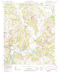
1948 Map of Salem
USGS Topo · Published 1974About this map
The Elk River winds through the borderlands of Alabama and Tennessee, defining a landscape of hollows and ridge-top settlements just as the post-war era transformed the region. The Elk River Fish Hatchery and the sprawling waters of the Wheeler Reservoir at elevation 556 demonstrate the mid-century engineering of the Tennessee Valley Authority. This topographic record highlights a dense network of rural infrastructure, from the Exeter Ferry Bridge crossing the river to a cluster of community centers like Gourdsville and Leggtown.
Find a feature on this map
74 named features on this map. Tap any name to fly to it.
Don’t see what you’re looking for? This feature index may not catch every label — zoom into the map to look around manually.
Map Details
Editions of this 1948 Salem Map
This is the sole edition of this map. No revisions or reprints were ever made.
Other maps of this area

1888 · Huntsville
USGS Topo · 1:125,000

1892 · Huntsville
USGS Topo · 1:125,000

1935 · Athens
USGS Topo · 1:24,000

1936 · Union Hill
USGS Topo · 1:24,000

1936 · Aspen Hill
USGS Topo · 1:24,000

1936 · Elkmont
USGS Topo · 1:24,000

1936 · Ripley
USGS Topo · 1:24,000

1936 · Appleton
USGS Topo · 1:24,000

1936 · Cairo
USGS Topo · 1:24,000

1936 · Elkton
USGS Topo · 1:24,000