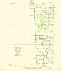
1936 Map of Salem
USGS Topo · Published 1936About this map
Novi and Northville townships are defined by a grid of agricultural section roads and early 20th-century institutions in this 1936 survey. Large institutional footprints such as the Detroit House of Correction, Wayne Training School, and Maybury Sanitarium occupy significant acreage along the Oakland and Wayne County line, reflecting a period when such facilities were established on the outskirts of metropolitan Detroit. The landscape is primarily rural, dotted with country schools including Stone Sch, Putman Sch, and Thayer Sch.
Find a feature on this map
39 named features on this map. Tap any name to fly to it.
Don’t see what you’re looking for? This feature index may not catch every label — zoom into the map to look around manually.
Map Details
Editions of this 1936 Salem Map
This is the sole edition of this map. No revisions or reprints were ever made.
Other maps of this area

1902 · South Lyon
USGS Topo · 1:62,500

1904 · Ann Arbor
USGS Topo · 1:125,000

1905 · Wayne
USGS Topo · 1:62,500

1906 · South Lyon
USGS Topo · 1:62,500

1907 · Pontiac
USGS Topo · 1:62,500

1908 · Ann Arbor
USGS Topo · 1:125,000

1909 · Milford
USGS Topo · 1:62,500

1912 · Wayne
USGS Topo · 1:62,500

1936 · Wayne
USGS Topo · 1:31,680

1936 · Wixom
USGS Topo · 1:31,680
Featured Places
- Novi, MI
- Northville Charter Township, MI
- Plymouth Charter Township, MI
- Lyon Charter Township, MI
- Wixom, MI