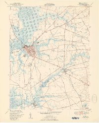
1951 Map of Salem
USGS Topo · Published 1951About this map
Salem River and the extensive Mannington Meadow define this landscape of South Jersey, where tidal marshes meet early colonial settlements. The city of Salem serves as the regional hub, its streets leading to historic landmarks like Majors Wharf and the Evergreen Cem. Transportation patterns are dictated by the waterways and the Pennsylvania Seashore Lines, which connects small rural clusters such as Welchville and Fenwick. To the south, Quinton sits along the banks of Alloway Creek, surrounded by productive lands and family-named woods. The map reveals the intricate drainage and bridge system required for this coastal plain, notably at Hancocks Bridge and the New Bridge crossing. Local education and civic life are anchored by several rural schools, including Town Hall Sch and Wyncoop Sch, while industry is represented by sites like Woods Upper Mill.
Find a feature on this map
76 named features on this map. Tap any name to fly to it.
Don’t see what you’re looking for? This feature index may not catch every label — zoom into the map to look around manually.
Map Details
Editions of this 1951 Salem Map
2 editions found
Other maps of this area

1890 · Salem
USGS Topo · 1:62,500

1890 · Bay Side
USGS Topo · 1:62,500

1894 · Bay Side
USGS Topo · 1:62,500

1898 · Salem
USGS Topo · 1:62,500

1899 · Vineland
USGS Topo · 1:125,000

1899 · Dover
USGS Topo · 1:125,000

1901 · Camden
USGS Topo · 1:125,000

1904 · Wilmington
USGS Topo · 1:62,500

1906 · Dover
USGS Topo · 1:125,000

1906 · Wilmington
USGS Topo · 1:62,500
Featured Places
- Pennsville Township, NJ
- Salem, NJ
- Quinton Township, NJ
- Lower Alloways Creek Township, NJ
- Alloway Township, NJ