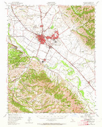
1947 Map of Salinas
USGS Topo · Published 1964About this map
Salinas and the adjacent community of Alisal anchor this mid-century survey of the lower Salinas Valley, captured during a period of significant agricultural and institutional expansion. The map detail reflects a complex landscape where the industrial footprint of the Southern Pacific railroad meets the deep-rooted ranching history of the Salinas River basin. Of particular interest to local historians is the sugar beet industry's influence, centered around the company town of Spreckels, and the intricate system of sloughs like Alisal Slough and Buena Vista Slough that once defined the valley's drainage.
Find a feature on this map
96 named features on this map. Tap any name to fly to it.
Don’t see what you’re looking for? This feature index may not catch every label — zoom into the map to look around manually.
Map Details
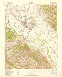
Editions of this 1947 Salinas Map
2 editions found
Other maps of this area

1910 · Gonzales
USGS Topo · 1:31,680

1910 · Salinas
USGS Topo · 1:31,680

1910 · Soledad
USGS Topo · 1:31,680

1912 · Salinas
USGS Topo · 1:62,500

1912 · Capitola
USGS Topo · 1:62,500

1913 · Monterey
USGS Topo · 1:62,500

1914 · Capitola
USGS Topo · 1:62,500

1915 · Soledad
USGS Topo · 1:62,500

1915 · San Juan Bautista
USGS Topo · 1:48,000

1917 · San Juan Bautista
USGS Topo · 1:62,500