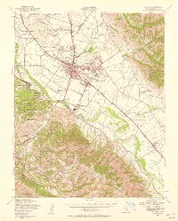
1947 Map of Salinas
USGS Topo · Published 1957About this map
Salinas and its agricultural hinterland are captured here during the post-war expansion of the late 1940s, showing the city's growth alongside industrial landmarks like the Power Plant and the local Southern Pacific rail infrastructure. The landscape is defined by a series of historic Spanish and Mexican land grants, including Nacional and La Natividad, which dictated the early pattern of ownership and settlement in Monterey County. To the west, the Fort Ord Military Reservation dominates the coastal ridges, featuring specialized training areas such as Machine Gun Flats and the Rifle Range.
Find a feature on this map
93 named features on this map. Tap any name to fly to it.
Don’t see what you’re looking for? This feature index may not catch every label — zoom into the map to look around manually.
Map Details
Editions of this 1947 Salinas Map
2 editions found
Other maps of this area

1910 · Gonzales
USGS Topo · 1:31,680

1910 · Salinas
USGS Topo · 1:31,680

1910 · Soledad
USGS Topo · 1:31,680

1912 · Salinas
USGS Topo · 1:62,500

1912 · Capitola
USGS Topo · 1:62,500

1913 · Monterey
USGS Topo · 1:62,500

1914 · Capitola
USGS Topo · 1:62,500

1915 · Soledad
USGS Topo · 1:62,500

1915 · San Juan Bautista
USGS Topo · 1:48,000

1917 · San Juan Bautista
USGS Topo · 1:62,500