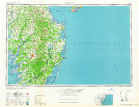
1965 Map of Salisbury
USGS Topo · Published 1965About this map
Salisbury stands as the central hub of this mid-century Delmarva Peninsula study, surrounded by the intricate drainage networks of the Wicomico River and the Nanticoke River. The map highlights a coastal landscape defined by significant maritime and military infrastructure, including the Fort Miles Military Reservation near Cape May and the Brandywine Shoal Lighthouse in the Delaware Bay. The geography transitions from the agricultural heartlands around Seaford and Georgetown to the barrier islands and sounds of the coast, where the Ocean City Seaplane Base and Fenwick Island Lighthouse guided mid-century transit. To the south, the isolated reaches of Smith Island and Bloodsworth Island sit within Tangier Sound, reflecting a period when maritime trade and seafood centers like Crisfield were foundational to the local economy. This survey documents the region's complex shoreline before modern coastal developments heavily altered the Sand dunes and marshlands.
Find a feature on this map
185 named features on this map. Tap any name to fly to it.
Don’t see what you’re looking for? This feature index may not catch every label — zoom into the map to look around manually.
Map Details
Editions of this 1965 Salisbury Map
This is the sole edition of this map. No revisions or reprints were ever made.
Other maps of this area

1884 · Sea Isle
USGS Topo · 1:62,500

1888 · Cape May
USGS Topo · 1:62,500

1888 · Dennisville
USGS Topo · 1:62,500

1888 · Sea Isle
USGS Topo · 1:62,500

1890 · Maurice Cove
USGS Topo · 1:62,500

1891 · Maurice Cove
USGS Topo · 1:62,500

1893 · Cape May
USGS Topo · 1:62,500

1894 · Dennisville
USGS Topo · 1:62,500

1894 · Sea Isle
USGS Topo · 1:62,500

1898 · Choptank
USGS Topo · 1:125,000