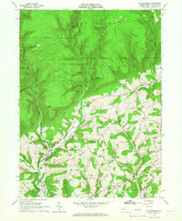
1965 Map of Salladasburg
USGS Topo · Published 1967About this map
Salladasburg sits at the confluence of several vital waterways in Lycoming County, dominated by the winding path of Larrys Creek and its many tributaries. The mid-1960s landscape shows a distinct division between the dense woodlands of State Game Lands No 114 and the agricultural clearings to the south. Local heritage is preserved in the location of Anthony Church, St Johns Church, and the Township Cemetery, which served the rural communities of Anthony and Mifflin townships. The map also documents the industrial activity of the era, from the upland Strip Mines in Cogan House to the Filtration Plant and Pumping Station infrastructure. Geographic landmarks like Harris Point and Clapp Point rise above the deep hollows, such as Spook Hollow and Pot Lick Hollow, that define the local terrain north of the settled valleys.
Find a feature on this map
54 named features on this map. Tap any name to fly to it.
Don’t see what you’re looking for? This feature index may not catch every label — zoom into the map to look around manually.
Map Details
Editions of this 1965 Salladasburg Map
2 editions found
Other maps of this area

1921 · Williamsport
USGS Topo · 1:48,000

1921 · Trout Run
USGS Topo · 1:62,500

1921 · Lock Haven
USGS Topo · 1:62,500

1923 · Lock Haven
USGS Topo · 1:62,500

1923 · Trout Run
USGS Topo · 1:62,500

1923 · Williamsport
USGS Topo · 1:62,500

1935 · Waterville
USGS Topo · 1:24,000

1937 · Waterville
USGS Topo · 1:48,000

1943 · Waterville
USGS Topo · 1:62,500

1944 · Trout Run
USGS Topo · 1:62,500